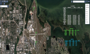
The AirBOSS Live, Real Time Web Tracking display system was designed to provide personnel at fixed locations with a browser-based means for monitoring operations airside at a facility. The AirBOSS System will generate flight track intel data of aircraft equipped with ADS-B transponder; FAA surveillance data, integrated IFR fight plan data, and digital GIS NOTAMS on a web-based portal for airport use. The AirBOSS solution puts flight data in the hands of Airport Operations and other stakeholders to improve Collaborative Decision Making (CDM) / Surface Management System (SMS) and accurately track aircraft and vehicles within the air operations area (AOA). Through its integrated ground vehicle tracking, the system also improves real-time situational awareness and alerts by displaying the location of operations, emergency, and maintenance vehicles on the same common operational web display. The real-time presentation of aircraft last mile to the stands and vehicle locations, flight plan data and NOTAMs to all stakeholders at an airport greatly improves safety and efficiency.
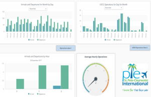
Statistical Executive Reports allows airport administrators to derive the benefit of statistical analysis from data collected by the AirBOSS system. The Executive Dashboard provides a clean and intuitive graphical representation of key performance indicators at the airport. The dashboard and related reports are customized for each airport operational needs.
The AirBOSS solution set puts the right data in the hands of Airport and stakeholders that are committed to improving the way they deliver services by implementing new technologies that enable administrators, operations, and personnel to improve safety and security, increase efficiencies, optimize performance and simultaneously reduce operating costs.
AirBOSS Web Based Situational Awareness Display
This real-time, web browser-based application is designed to provide a cost effective display for personnel at the various airport operations, coordination locations (i.e. airport operations center or executive management teams, ARFF stations) and the general public if approved by airport (Read Only Replay Tool). The ability to view flight and vehicle location data in and around the airport improves coordination of airport services and identifies who using those services. By combining data, this low-cost tool is a powerful collaboration and decision making platform that is available to a wide range of stakeholders.
The AirBOSS web display with its open architecture provides a means to display flight and ground vehicle data from multiple surveillance sensors and third party commercial flight data services. The Web platform provides a powerful, secure and private, situational awareness display giving users a common operating picture (COP) of the airport and surrounding areas.
Executive Dashboard and Operations Reports
Collaborative Decision Making (CDM) of your Airports Surface Management System is key for increased safety and lower operational costs. The AirBOSS executive dashboard allows airport administrators to derive the benefit of statistical analysis from data collected by the AirBOSS system. Not only does the AirBOSS Executive Dashboard provide a clean and intuitive graphical representation of key performance indicators at the airport, but also serves as a gateway to access operational data in common formats such as .CSV or compatible for use in Microsoft Excel. The dashboard and related reports are customized for each airport operational needs. The airport operations data will be stored for 12 months; additional data storage is available based upon record retention needs of the airport.
Driver Situational Awareness and Alert System (DASA)
NavAid is an authorized re-seller of OpsBOSS Vehicle Tracking Transponder (VTT) technologies which offer the greatest flexibility in vehicle tracking and alert technology available to airports.
The Driver Situational Awareness and Alert System (DASA) allows an airfield vehicle operator to maintain situational awareness of their position and the position of other AirBOSS transponder equipped vehicles on the airfield. The application serves the driver by displaying, in real-time their position from the embedded GPS on their cellular iPad device over a highly accurate map that is developed from the airports own GIS system. In addition to presenting the user with a simple, intuitive and accurate representation of their own location on the airfield, the system also alerts the driver when the location of the vehicle is inside an airfield defined geo-fenced area, like a runway, hold short line or other hazardous location in and around the airfield. To further enhance the benefit of the application, the location of other vehicles equipped with the various AirBOSS vehicle tracking solutions, is also displayed for the driver. This unique feature of the system allows a vehicle operator to quickly and accurately identify other resources in the airfield.
If your needs do not require an FAA compliant surveillance, tracking outside the movement area or your airport is not equipped with an ASDE-X or ASSC system, AirBOSS DASA transponders are your newest innovative solution. Regardless of which model is best suited for your airport’s needs, they are all tightly integrated with the AirBOSS Software Suite.
- GSM Vehicle Tracking Transponders (VTT)
- Highly accurate GIS maps
- Geo-fenced audible & visual alerts to the driver
- Vehicles tagged for identification and speed
- Notification of supervisors vehicles in protected areas
- Common operational view resources & aircraft on AirBOSS Web portal
- Permanent or Portable VTTs for contractors, maintenance, ARFF, & Ops vehicles
- Improve safety in all areas of the airfield, airside and landside
- Situational awareness during normal and irregular operations
- Low Implementation and Operating Costs
- Cost-effective incident command & control display of critical resource

AirBOSS is the only, RIWS designed, built and tested to comply with the FAA’s AC 150/1520-25, that is available on multiple platforms like Windows and Apple iPads. As an RIWS, the system is specifically designed to prevent the unintentional entry  of a vehicle into the RSA or other airport defined protected areas. This is accomplished by preemptively giving the driver visual and audible warnings as the vehicle approaches a protected zone. Warnings have been designed to provide the driver with sufficient time to make speed and course corrections necessary to prevent an incursion, not just to alert the driver or controller after the fact.
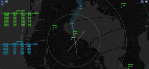
The AirBOSS Web display system was designed to provide personnel at fixed locations with a browser-based means for monitoring operations airside at a facility. The tool displays for users the position of all vehicles equipped with UAT VMAT units or those with the AirBOSS RIWS platform, on custom views generated from the airport’s own GIS-based map files. In addition, with its interface to ASDE-X surveillance data system at HNL, the AirBOSS Web platform provides a powerful situational awareness display giving users a common operating picture (COP) of the airport and surrounding areas. AirBOSS Web also receives position reports from vehicles equipped with the AirBOSS RIWS system or optional dual frequency VMAT, over cellular connections, allowing for the tracking of vehicles anywhere on the airport surface and beyond the movement area broadcast map of the UAT VMAT tracking system. INDMEX has entered into various agreements and memorandums of understanding to receive live surveillance data from a multitude of sources including the FAA’s System Wide Information Management (SWIM) program. Real-time surface surveillance data for US airports has been available as part of the AirBOSS system since August 2015 and includes flight track data for ASDE-X equipped airports.
This capability allows AirBOSS and its mobile component, AirBOSS RIWS, to display in near real-time the position of aircraft and to provide key information for each flight track including:
- Identification of a flight (Arrivals or Departures)
- Vehicle or Flight ID
- Aircraft or Vehicle Type
- Altitude
- Transponder Address
- Flight Origin and Destination
The ability for an airport to deploy a web-based, real-time, situational awareness display to a wide range of personnel, through a cost-effective tool allows an airport to effectively share information across a wide range of critical personnel and improves collaboration during all aspects of operations.
AIRBOSS Digital Runway Incursion Warning System (D-RIWS) is a light, portable, runway incursion prevention system with vehicle tracking capacities that can be deployed on smart phones like Apple iPhone’s. The system uses the same predictive alerting logic of a certified RIWS platform, including visual and audible alerting of a driver, without requiring installation of dedicated computers or tablets in a vehicle. D-RIWS has been designed to leverage existing clients telephones and tablets, by focusing on the alerting capability. Advanced Geo-Fencing and Alerting capabilities for: Airfield Inspection, Lawn Mower Operations, Maintenance Personnel, Emergency Responders and Snow Removal. See Product Sheets for More Information.

NavAid Technical Services will prepare and implement an Integrated Support Plan (ISP) that establishes the essential information required to initiate and maintain a comprehensive logistics support program for the life cycle of the fielded systems. The ISP shall be a living document that NavAid Technical Services will use to manage the Integrated Logistic Support Program (ILS) activities for “Customers” Fielded Systems.
The ISP addresses key activities including:
- Maintenance and Support Planning
- Second Level Engineering Support Services
- Supplying, Replenishing and Repairing Spares
- Reliability, Maintainability, and Availability (RMA) Tracking
- Configuration Management
- Notification of and Supplying Engineering Changes
- Notification of and Supplying Software Upgrades
- Maintain Customer Support Service Records and Provide Reports
- Provide Technical Support
- Packaging, Storage, and Transportation of System Components